 The west coast of Australia was known as New Holland after being charted by Dutch trading ships when they were blown off course on the way to the Spice Islands of Molucca (now Maluku Islands).
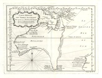
A number of earlier cartographers (map draughtsmen) showed vague outlines of an imaginary east coast. In the middle of the 18th century French theoretical mapmakers created two spectacularly misshapen versions and published them alone - without Asia or other countries. Seventeen years before Captain Cook charted the east coast of Australia, Jacques Nicolas Bellin's map circa1753 (now the most famous antique map of Australia with inaccurate east coast) showed an undulating line joining Van Diemen's Land (Tasmania) to what was known of New Guinea - via Terre du St Esprit (New Hebrides/Vanuatu, but west of actual position). Along this dotted line is written in French, that Bellin "supposed" the east coast of New Holland "mais sans preuve"(but without proof).
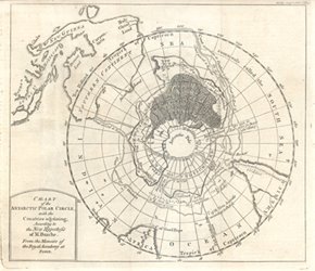 Ten years later c1763 a Chart of the Antarctic Polar Circle with the Countries Adjoining, According to the Hypothefis of Monsieur Buache from the Memoirs of the Royal Academy at Paris was published. (s was often shown as f)
Philippe Buache worked with his father-in-law, Guillaume Delisle who was premier géographe du roi (royal geographer) from 1718 and based most of his maps on astronomers' findings. Buache succeeded Delisle as geographe du roi in 1729. Buache's wonderful map shows many other cartographers' discoveries and theories of Antarctica, with "Land yet undiscovered" and "Frozen sea as supposed", "a land and ice spotted by sailors" and the dates as noted by cartographers, including Abraham Ortelius and Petrus Kaerius’ in the late 16th century.
Buache's hypothesis of the balance of land masses between the north and south world spheres, is superimposed over Antarctic Polar Circle, with New Holland/Southern Continent intersected by Tropick of Capricorn - which extends in the east to Holy Ghost Land in the vicinity of Vanuatu.
These are the best early Australian maps for any collector. Both are currently for sale through Antique Print Club website at Bellin, Reduced Chart of Southern Lands and Buache, Antarctic Polar Circle