John Tallis established his name soon after he moved to London from Birmingham to assist his father between 1838 and 1840 with publication of one of London’s earliest street directories - pamphlets entitled London Street Views. They contained street elevations with many occupants named on their building (for a fee), which was one of John Tallis's earliest innovative advertising ideas. Advertising space was sold – not only to businesses within the vicinity covered by each central London pamphlet, but also to introduce new products and innovations.
A few years later John Tallis and his brother Frederick set up the J. & F. Tallis Publishing Company to produce well-detailed, finely engraved decorative steel-engraved maps. Their business expanded with offices in London, Edinburgh & Dublin, but the partnership was dissolved in 1849. The first edition of Tallis maps for The Illustrated Atlas, and Modern History of the World, Geographical, Political, Commercial & Statistical was edited by R. Montgomery Martin, Esquire and published in parts between 1849 and 1851 under the J. & F. Tallis name. The periodically issued parts were usually compiled and grandly bound within fine covers, but through much handling over the intervening years the bindings and contents usually progressively deteriorate. Maps are available on our website in the sections for different countries - or simply enter Tallis in the Search Bar of our website Home page.
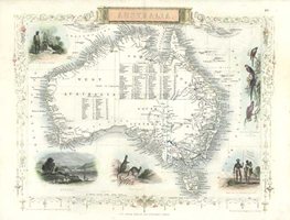
(Please email sales@antiqueprintclub.com if you are interested in purchasing a volume of the 1853 edition of Martin's "Australia" with gold discovery regions shown.)
During preparations for The Great Exhibition of London, London Street Views was re-issued as Tallis’s Illustrated London: in Commemoration of the Great Exhibition of All Nations in 1851. It was a long title but ensured international recognition. The Illustrated Atlas, Modern History of the World was also updated and re-issued in 1851 and established Tallis’s reputation worldwide, with offices in London and New York.
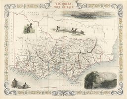
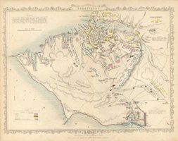
The engraver, John Rapkin, was responsible for the quality of the maps produced by Tallis and Company, and for ensuring that the steel-engraved plates for the later editions were updated to the current information as far as possible. Tallis and Company were known for the distinctive style of their steel-engraved maps and prints. Their maps were highly regarded not only for their geographical accuracy but also for their decorative presentation. Tallis employed specialist map artists and engravers to add finely engraved borders and small engraved vignettes that show important places, people, flora and fauna relative to the region.
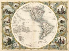
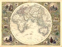
The heaviest and most intricate embellishment of all Tallis maps are the pair of maps of the Eastern Hemisphere and Western Hemisphere. Each map sphere is surrounded by a wide border incorporating wildlife and people in their native costumes, as if seen through ‘windows’ formed by elegantly entwined vines.
Tallis published maps of most countries. The map of Australia was accompanied by 6 maps of the Australian States, the world voyages of Captain Cook, and the trading routes round the world from Great Britain. The maps were reissued a number of times with updated information. At the end of 1853 John Tallis formed The London Printing and Publishing Company with Ephraim Tipton Brain who had similar interests in publishing. They continued the traditional Tallis style of presentation until the elaborately engraved borders and fine embellishment were considered too slow and expensive. Later maps were printed on finer paper and without the decorative vignettes.
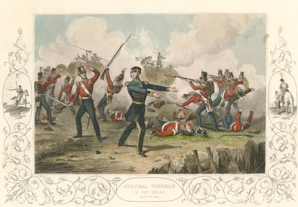
The final Tallis publication with intricately engraved decoration was The Illustrated History of the War with Russia published in 1856 by The London Printing and Publishing Company. The military personnel and battle scenes frequently had small related military subjects engraved in the margins at the side and below – often enclosed by swirling engraved lines. The quality of engraving that had been established by John Tallis was maintained with the subsequent publication of these portraits, and action scenes but later editions were issued more economically, without the traditional Tallis-style of embellishment.
Despite considerable local and international recognition from publication of finely engraved maps and prints, John Tallis’s fame in London was established with the publication of London Street Views, and he has been honoured at 23 New Cross Road where he lived. It is now a Grade II Listed Property and on the wall is a blue plaque with “John Tallis 1816-1876 Publisher of London Street Views lived here.” John Tallis published the last decorative maps of the world, and internationally they will always be his greatest legacy.
Having dealt internationally in antique maps and prints for nearly 40 years, we have numerous examples of most maps and prints but many are not yet on our website, so if you can't find what you are looking for please contact me.