In Northern Europe in 1472 the first woodblock map was published by inking a raised type-face that had been created by carving away from the image to be printed. In Italy a different process was soon developed to show the fine detail of each map by copperplate engraving.
Engraving for the printing of images was painstaking and highly skilled work. Engraving was made more difficult by having to be done in reverse as a mirror image, so that the image was the right way round when printed for publication. Early maps were printed on hand-made paper. Both the paper and the copperplates were expensive. Fortunately carved lines on copperplates could be beaten flat and re-engraved with updated information.
Long before the invention of the printing press (around 1440) 'the father of cartography', Claudius Ptolemaeus (87-150) based his theories of the universe on those of the ancient Greeks. Ptolemy was a Greek mathematician, geographer, astronomer and astrologer who lived in Alexandria when it was the most important centre of learning in the world, and the centre of trade between east and west.
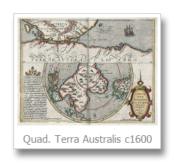
Ptolemy's most important works were Almagest on astromony using grid structure and mathematical projections for maps, and the terms ‘latitude’ and ‘longitude’). Ptolemy theorised that there must be a great south land to balance the weight of the known land masses of the northern hemisphere, to balance the world and keep the earth from tipping up. His theories were maintained for over 1,500 years.
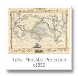
In the 16th century, the most important period in the development of map-making, Gerardus Mercator (1512-1594) was a mathematician, cartographer, designer of mathematical instruments, and globe-maker. Mercator drew and engraved his first map (of Palestine) in 1537, but he established his fame in 1569 with an enormous eighteen-sheet World Map, drawn to his new ‘Mercator Projection’ with increasing latitudes. 'Mercator's Projection' can be found at the top of many flat projections of the world that have been published over the years since. Although he was not the inventor of this type of projection, Mercator was the first to apply it to navigational charts so that compass bearings could be plotted in straight lines which greatly assisted navigation. Mercator also designed instruments to improve the method of land surveying. Mercator’s appreciation of design extended to his copperplate-engraving of maps, and his introduction of decorative italic wording.
Gerard Mercator re-engraved, as closely as possible, the maps for a new edition of Ptolemy's Geographia, and published a three-part Atlas which was known as 'The Mercator Atlas'. Mercator was the first to refer to a book of maps as an Atlas (named for the learned philosopher, mathematician and astronomer, the legendary King of Libya).
Abraham Ortel (1528-1598), known as Ortelius, is credited with the first formal world atlas, Theatrum Orbis Terrarum published in 1570. It was the first book containing a systematic collection of equal-sized maps, compiled from contemporary knowledge and not based on Ptolemy's theories.
Ortelius worked in the great commercial centre of Antwerp.
He travelled widely throughout Europe and used his cartographer contacts to gather maps which he drew and Frans Hogenberg engraved. The Ortelius Theatrum appeared in numerous editions up until 1612 - in different languages, and each time updated with the latest knowledge and discoveries. Ortelius shared information of the latest discoveries with Mercator who encouraged and advised him. Being more commercially minded than Mercator, Ortelius also adapted Mercator’s maps for his own publications.
Original engraved maps prior to the 16th century are rarely seen today. Surprisingly, considering the fragility of paper, a wide range of 17th, 18th and 19th century antique maps are still available. As with antique prints of other subjects, the value of antique maps depends on rarity, quality and condition.. and demand.
You can buy an original map over one hundred years old for as little as $50 or for more than $15,000. Cost does not determine the amount of fascination they provide – from the paper and printing method used in making them, the wonder of their survival, and of course, the variation of information shown on them.
The inaccuracies of earlier coastlines now entertain us, but as centuries have changed political boundaries, the varying names and borders of regions and countries provide a graphic reminder of the past. The more you study them the more you are hooked - an affliction referred to as ‘map pox’!