In 1755 instead of accepting the position of Master of a collier with the Walker brothers, James Cook volunteered for the Royal Navy in the war between Great Britain and France. As Master's Mate on HMS Eagle in 1756-7 Cook so impressed Captain Hugh Palliser that Palliser's recommendation, together with that of John Walker, gained Cook the right to sit for his master's examination despite 4 years' less experience than usually required. After passing this examination in 1757 Cook was discharged from Eagle and appointed Master of Solebay, patrolling off Scotland.
At the end of the war Cook was appointed marine surveyor in Britain's new territories in north-eastern America (Canada). His meticulous surveys of Labrador and Newfoundland between 1763 and 1767, and his observations of an eclipse of the sun, were instrumental in his being chosen to lead a joint Royal Navy - Royal Society scientific expedition to the Pacific to observe the transit of Venus in Tahiti (to enable better calculation of the distance between the Earth and the Sun).
Cook charted the Society Islands (Tahiti), made observations of Venus and the Sun, and then opened his second Order... "Secret instructions for Lieutenant James Cook Appointed to Command His Majesty's Bark the Endeavour 30 July 1768"... to find the Great South Land, a 'Land of Great Extent', - shown on maps for hundreds of years as "Terra Australis Incognita" (Unknown Southern Land).
Tupaia, a Polynesian priest in Tahiti, could converse in several languages. He was an experienced navigator and wanted to travel with Cook. What a gift! He educated Cook on birdlife, flotsam, changes in water colour, currents and the winds. After much to-ing and fro-ing, including charting New Zealand, in 1770 Cook landed at Botany Bay (Sydney) on the east coast of Australia. He claimed the land for Britain, named it New South Wales, and then continued north, noting anchoring opportunities and taking depth soundings - until Endeavour's hull was damaged on the Great Barrier Reef.
As much as possible was thrown overboard to lighten the load, the hull damage was patched with sails, and rowboats amd sailors were lowered to tow them north into the Endeavour River (named by Cook). During the next 7 weeks while Endeavour was repaired where Cooktown now stands, James Cook travelled around the coast (naming the region The Labrynth), and Joseph Banks and his scientists explored while their artists drew and painted their findings. When they continued their journey north, they sailed around Cape York (naming Endeavour Straits) - by the most direct route to Batavia where Endeavour was properly repaired.
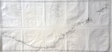
Cook's 1770 charts were the earliest records of the east coast of Australia. Without a chronometer for celestial readings they were remarkably accurate, and were used for sailors' navigation over the next 100 years.
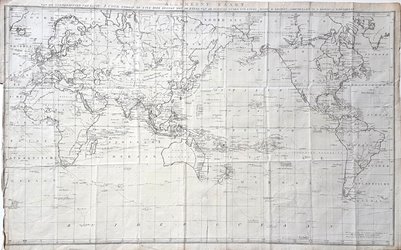
Cook's charts of Australia and the Pacific are available from Antique Print Club at https://www.antiqueprintclub.com/Captain-Cook-East-Coast-of-New-Holland.aspx