French Département maps
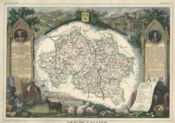
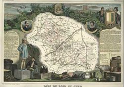
Creativity of cartography extends to the elaborate decorative narrative in Levasseur maps of the departments of France and her colonies. The ornate decoration included historic statistics, important people from the region, and trades and produce. Some of the most elaborately decorative maps ever published are the antique maps of the French Departments and Colonies by Victor Levasseur.
A French engineer, geographer and mapmaker, Victor Levasseur flourished as a mapmaker between 1838 and 1854. He established his reputation as a mapmaker with his French department maps which are some of the most easily recognisable.
First published in 1838, with maps 'Drawn after the Works of the Land Registry of the Military Depot and of the Bridges and Roads, by V. Levasseur, Geographic Engineering Attaché', his grand Atlas National Illustré was immensely popular and was issued a number of times until 1872. The edition published in Paris circa 1854 was particularly fine. Levasseur surrounded each map of a department with a beautifully engraved narrative of the region, including illustrations of produce, commerce, coats of arms, local landmarks, peasants in costume, historically important people and side panels of scrolls showing statistics of the period of the map. An example of Levasseur's beautiful maps is this map of the department of Gironde published in Paris. View them on our website at Antique Maps/French Departments